

Researchers from the STAMINA4Space Program, DOST-ASTI and PhilSA closely monitored the Typhoon Odette, generating maps of the affected areas to provide near real-time data and information to government agencies and the public.
The Philippines is no stranger to disasters, hence the extensive research and development efforts on science technology plans for disaster risk reduction. Managing disaster risks and events is now heavily dependent on scientific knowledge, whilst implementing evidence-based decision making.
Leveraging from the past and ongoing Department of Science and Technology-supported projects and related initiatives on disaster mitigation, the Advanced Science and Technology Institute (DOST-ASTI), together with the Space Technology and Applications Mastery, Innovation and Advancement (STAMINA4Space) Program and Philippine Space Agency (PhilSA) now conducts further research on remote sensing, geographic information system, data science, and space data technologies for DRRM and other geospatial applications.
Using datasets from earth observation satellites, we are now able to mobilize efforts through space science and technologies to complement the pre- and post- DRRM initiatives of national and local government agencies.
During the recent onslaught of typhoon Odette (International name: Rai)– which ravaged parts of Visayas and Mindanao in mid-December 2021– DOST-ASTI, STAMINA4Space, and PhilSA closely monitored the typhoon, generating maps of the affected areas to provide near real-time data and information to government agencies as well as the public.
The DOST-ASTI’s Remote Sensing and Data Science: DATOS Help Desk distributed flood impact maps and other datasets to national agencies with disaster management efforts. When there are available SAR datasets concurrent with hazards (flooding, landslide) events brought about by [extreme] weather conditions, DATOS, through its Artificial Intelligence models, detect the potentially inundated and affected areas. Such datasets are also posted on the DATOS Facebook page for public consumption and utilization.
Below are the links to the flood impact maps and other datasets distributed to agencies to aid their post-DRRM efforts:
- Regions I, II, CAR, III, IV-A, and IV-B | 18 December 2021 (~6:00 PM PST): https://bit.ly/3E3M3YY
- Regions VIII, X, XI, XII, XIII, and BARRM | 15 December 2021 (~6:00 AM PST): https://bit.ly/3oYKVl9
- Regions II, CAR, IV-A, and V | 14 December 2021 (~6:00 PM PST): https://bit.ly/3dSYNXG
- Regions IV-A, IV-B, V, VI, IX, and BARMM | 13 December 2021 (~6:00 AM PST): https://bit.ly/3ywNazl
Similarly, DOST-ASTI’s Philippine Earth Data Resource and Observation (PEDRO) Center consolidated all the satellite images of areas affected by the devastation of typhoon Odette for the DRRM actors to utilize and distribute as necessary. Here is the extent and coverage of capture:

Here are some satellite images taken through the PEDRO Center and processed by the DATOS) Help Desk and the STAMINA4Space Program.
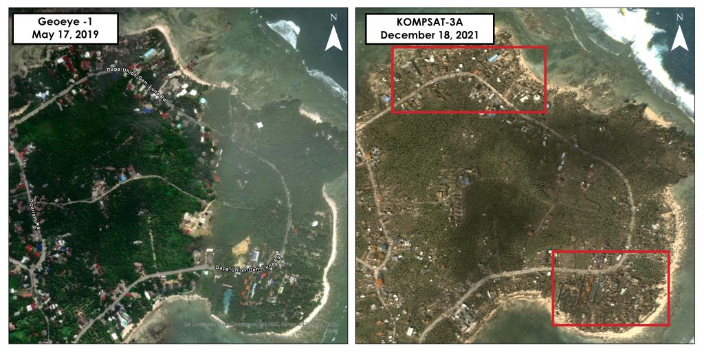
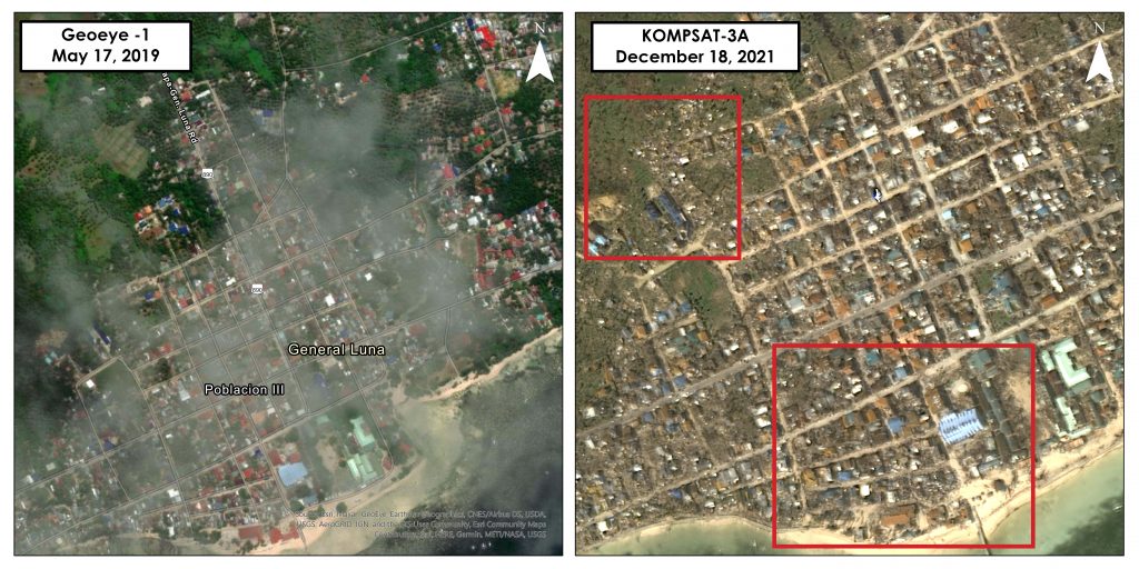
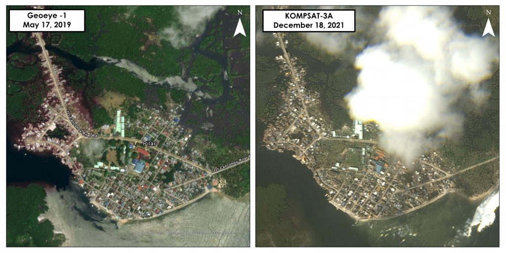
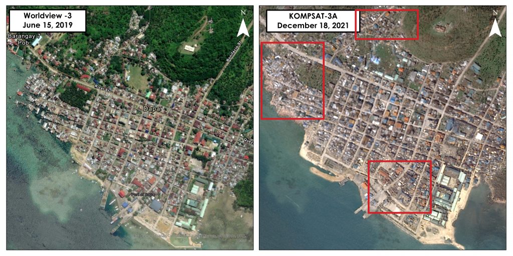
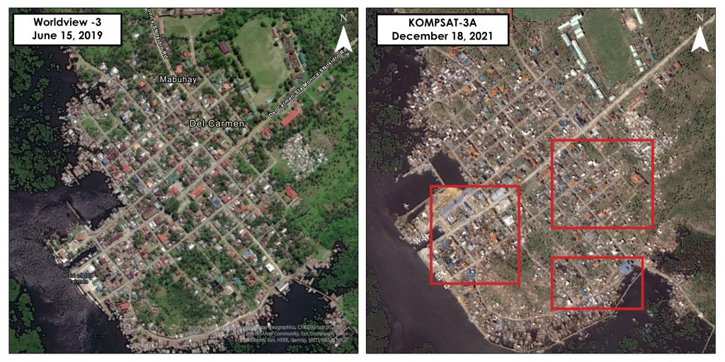
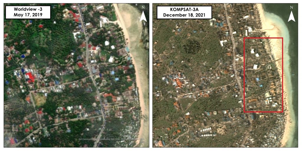
Siargao Island, Surigao del Norte
Typhoon Odette made its first landfall in the country on Siargao Island, Surigao del Norte last 16 December 2021. Using a KOMPSAT-3A image of the island taken 18 December 2021, only two days after the typhoon hit, researchers were able to show the extensive damage in the island as compared to pre-disaster images in 2019. Areas in red show possible damaged properties.
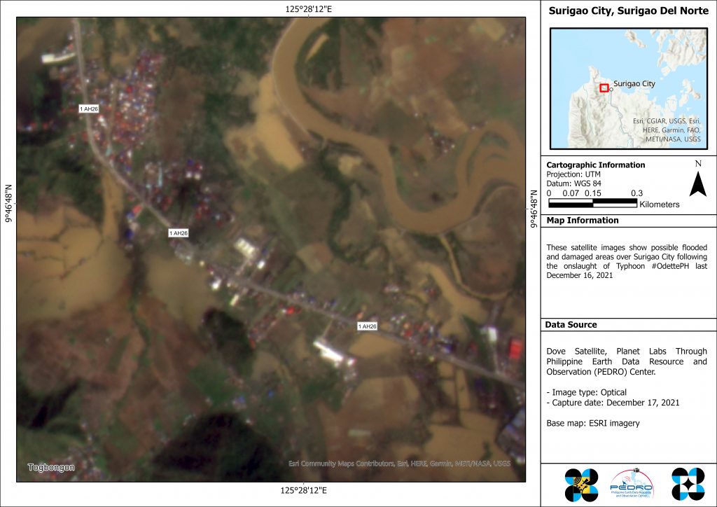
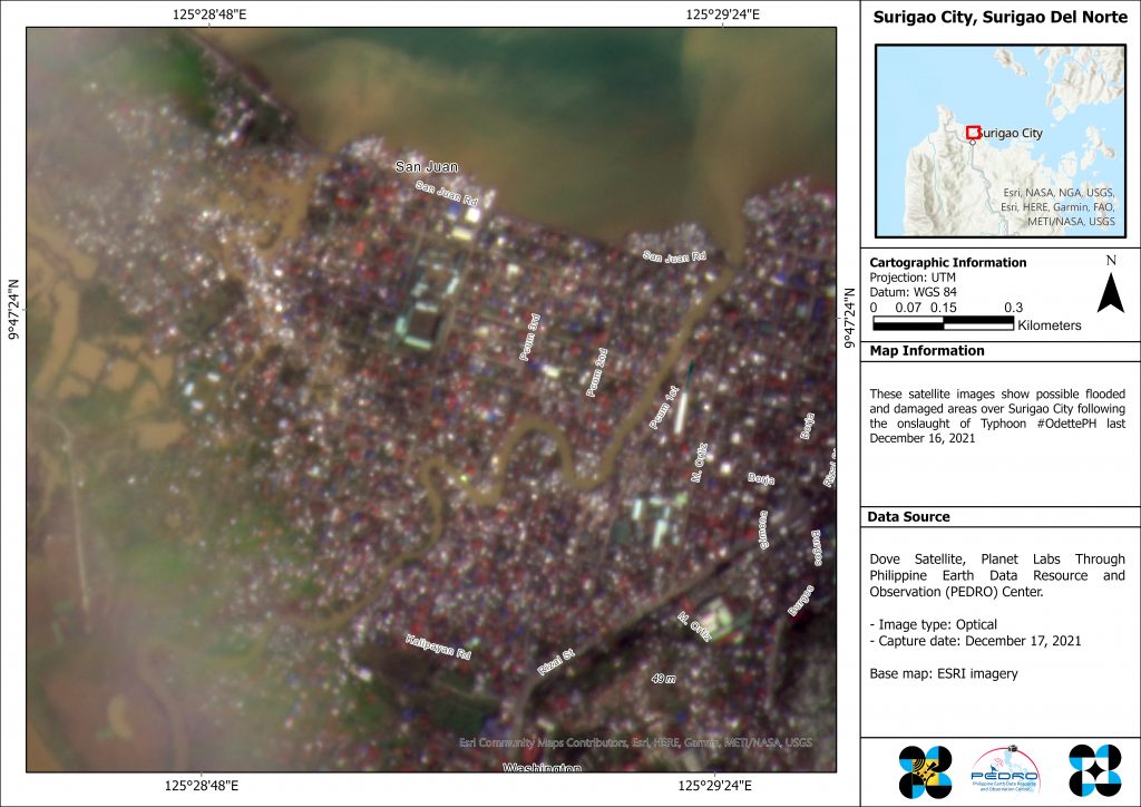
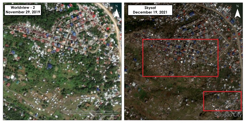
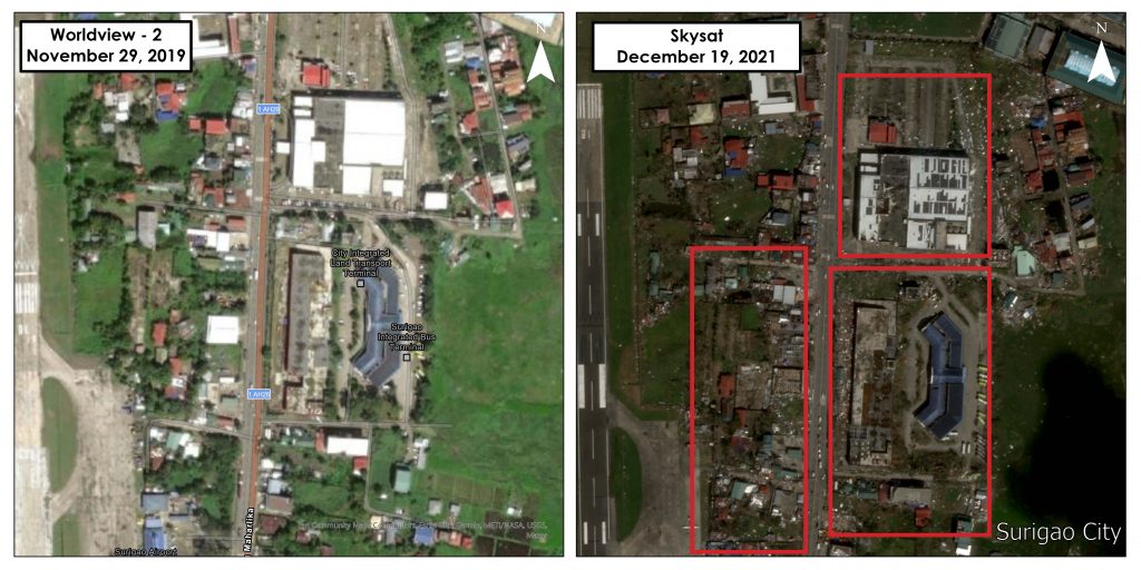
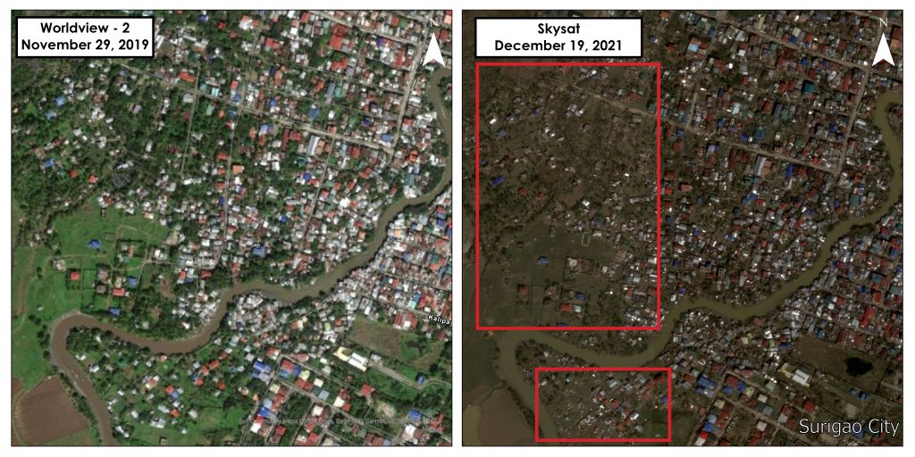
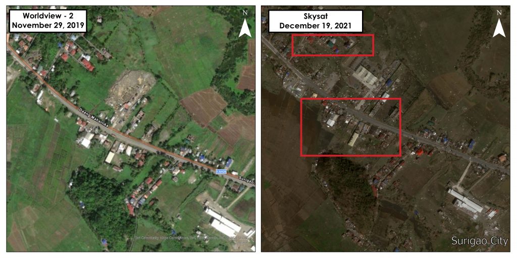
Surigao City, Surigao del Norte
According to the National Disaster Risk Reduction and Management Council’s (NDRRMC) latest report on the typhoon, around 54,000 families were affected by Odette in Surigao City¹.
In these images taken by PlanetScope last 17 December 2021, widespread flooding in the city can be observed.

In these satellite images that were taken by SkySat last 19 December 2021, possible destruction of infrastructure in the city are visible (areas inside the red boxes). According to the NDRRMC report, 49,000 houses were damaged by the typhoon in the city. Surigao del Norte suffered P8.1 billion damages to infrastructure and P1.1 billion damages to agriculture¹.

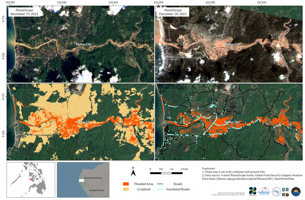
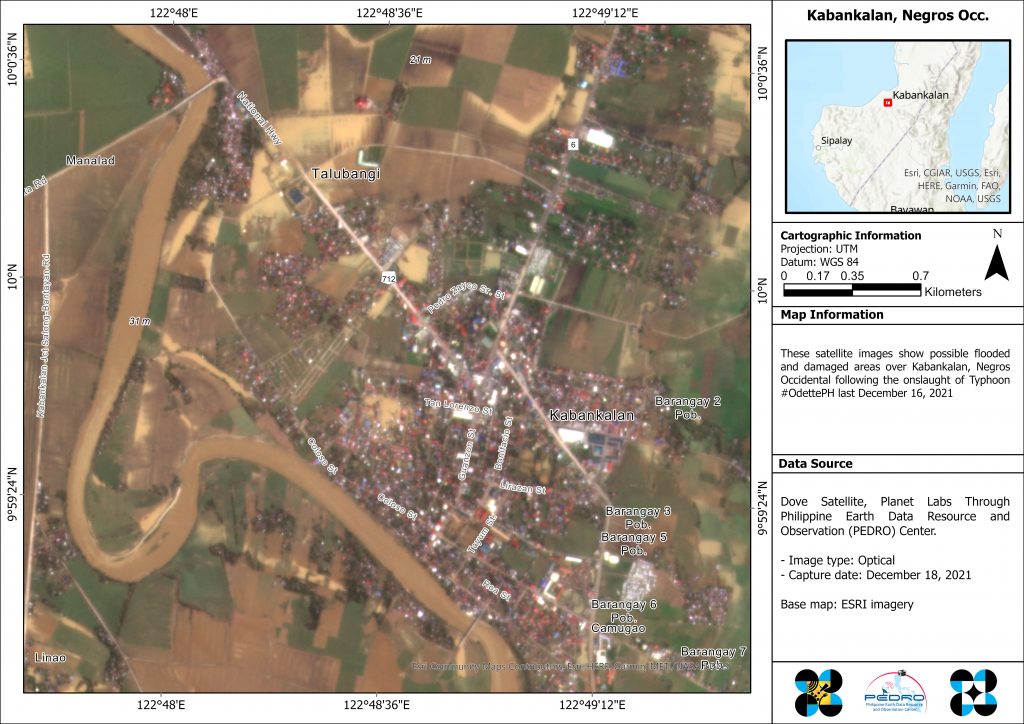
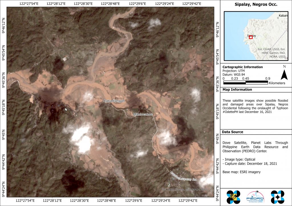
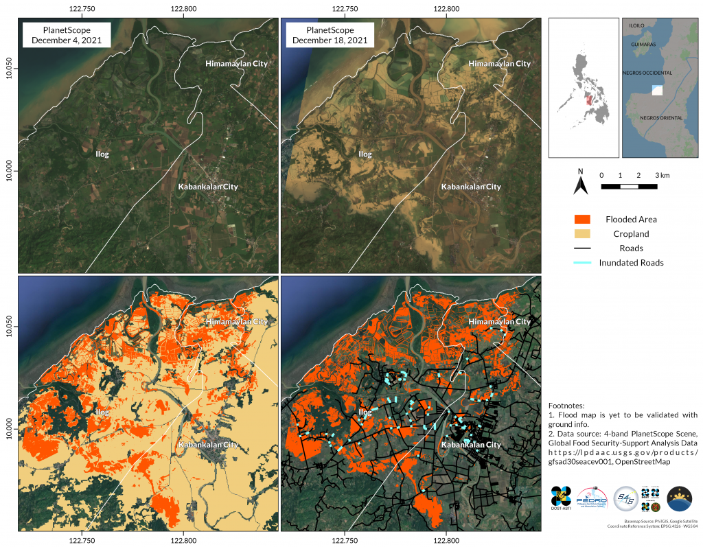
Ilog, Kabankalan and Sipalay, Negros Occidental
Odette also substantially ravaged some parts of Negros Occidental. Below are images of the cities of Kabankalan, Sipalay and Municipality of Ilog. According to the same NDRRMC report, around 68,000 families were affected with a total of 29 reported casualties in these three cities. In total, Negros Occidental suffered P3.9 billion in damages in agriculture¹.
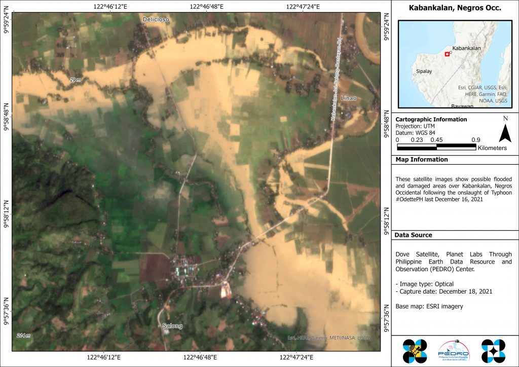
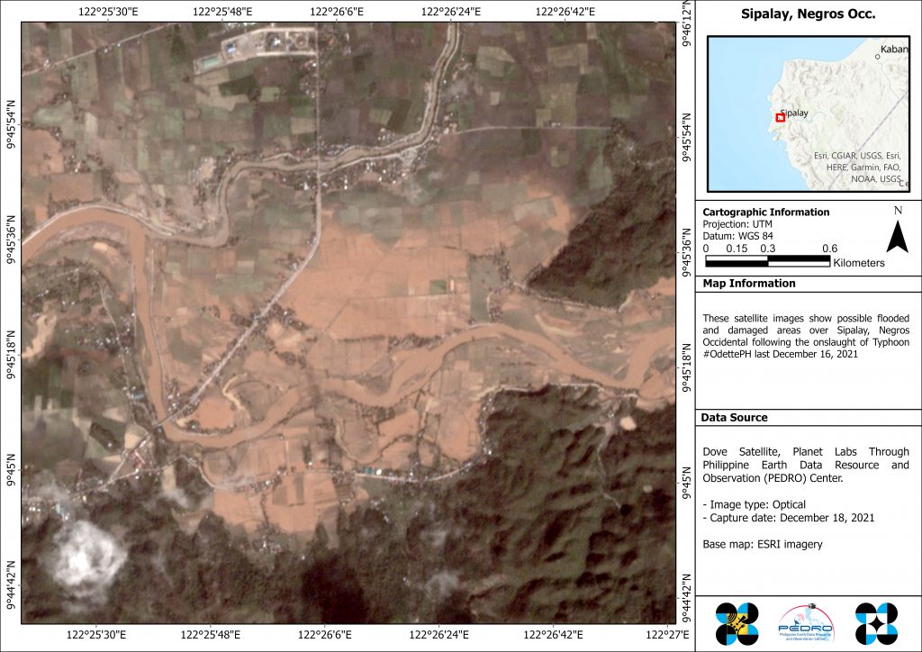
Researchers from STAMINA4Space Program were able to map the possible extent of flooding in the areas through a combination of Normalized Difference Water Index (NDWI) and thresholding technique, as well as map possible flooded roads.
The satellite image below shows a map of Kabankalan and Ilog taken last December 18, 2021. In this report, approximately 2,958.3 hectares (ha) of land was flooded, with ~2,351.6 ha of flooded cropland. According to NDRRMC’s report, Kabankalan City suffered P630 million damages in agriculture and the Municipality of Ilog some P 343 million¹.
Similarly, this satellite image shows possible flooded croplands and roads in Sipalay City. Approximately 689.5 ha of land was flooded, with ~458.8 ha of flooded cropland. The NDRRMC report stated Sipalay suffered P 382 million damages on agriculture¹.
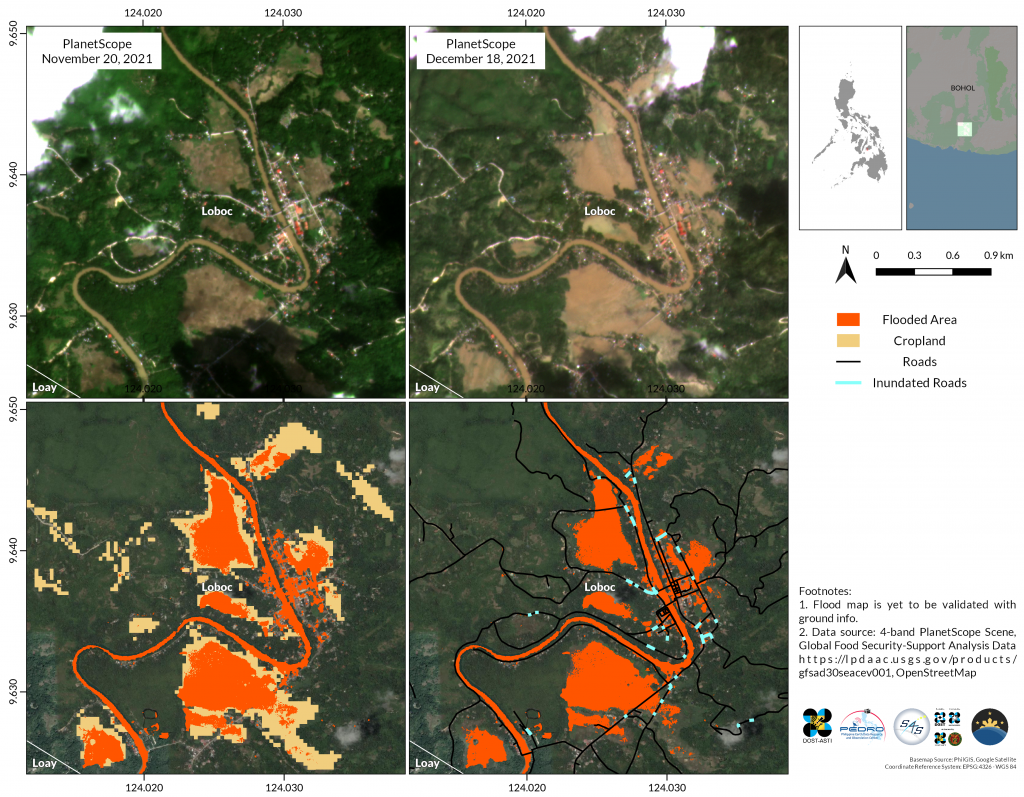
Loboc, Bohol
DOST-ASTI and STAMINA4Space Program monitored the flooding in Bohol as well. Images from PlanetScope taken on 18 December 2021 show the possible extent of flooding in Loboc, Bohol. Loboc suffered damages to infrastructure amounting to six million.
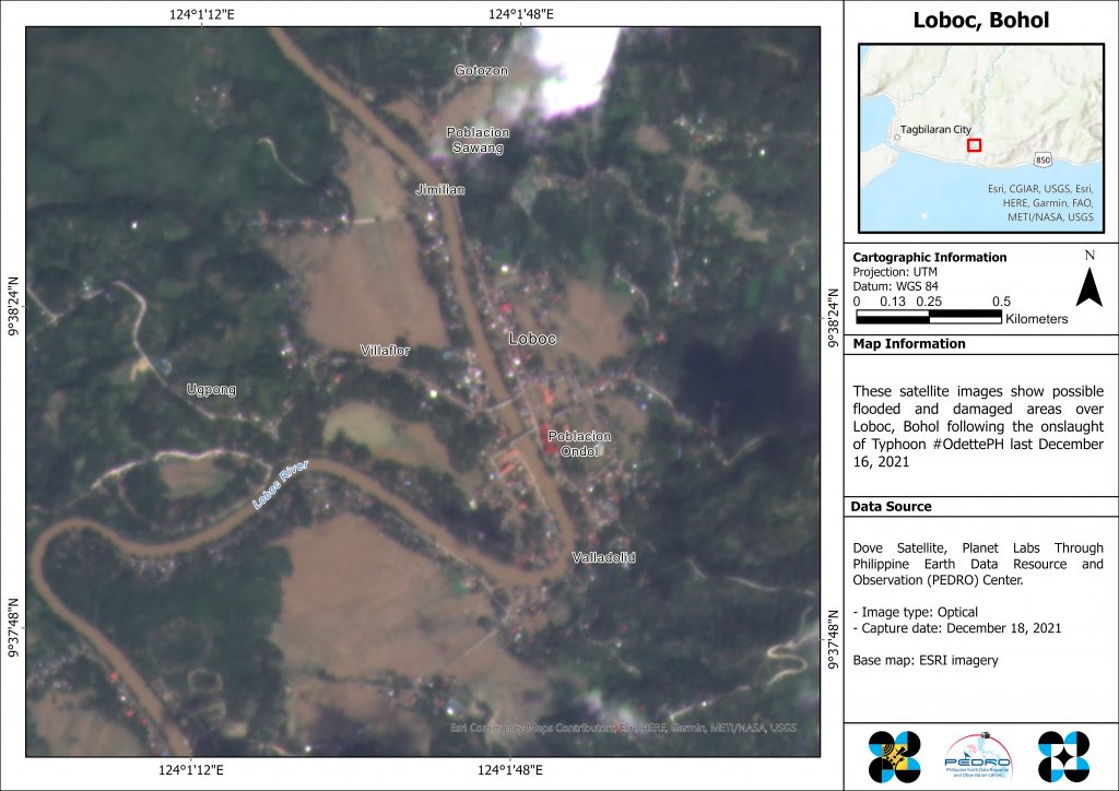
This map of the area shows possibly-flooded croplands and roads in Loboc. Approximately*113.2 ha of land was flooded, with ~73.1 ha of flooded cropland.
The satellite images were distributed to concerned agencies including Philippine Atmospheric, Geophysical and Astronomical Services Administration (PAGASA), Philippine Institute of Volcanology and Seismology (PHIVOLCS), Mines and Geosciences Bureau (MGB), Palawan Municipal Disaster Risk Reduction Management (MDRRM), DOST Regional Offices, DOST Office of the Secretary, Office of Civil Defense, NDRRMC, among other agencies.
SPACE TECHNOLOGY EFFORTS AND MOBILIZATION FOR DRRM
DOST-ASTI, STAMINA4Space, and PhilSA have also been initiating capacity and resilience building activities through available S&T infrastructures and research initiatives on earth observation (EO) applications. EO data, when properly used, can considerably combat the risks of climate change and disasters.
Check the consolidated report and prior initiatives in Space Science & Technology and Applications (SSTA) in the Philippines:
References:
¹ Situational Report for TC Odette (2021) https://ndrrmc.gov.ph/attachments/article/4174/SitRep_No.35_for_Typhoon_ODETTE_2021.pdf