
Diwata-2 High Precision Telescope (HPT) images, paired with a high-resolution Google Earth image from 2016, show new structures on previously unoccupied lands
Residential areas, new roads and mining sites — these were some of the new structures captured by Diwata-2’s High Precision Telescope (HPT) on March 21, 2019 as seen in the images below. The HPT is one of the Philippine microsatellite’s on-board cameras which has the capability to capture images at 5 meter resolution.
In these images, paired with high-resolution Google Earth images from 2016, Diwata-2’s HPT was able to capture something else: significant land use changes in a span of three years. In the image below, for example, it shows that an approximate of 9.45 ha of agricultural areas were converted to residential areas, while 3.08 ha were turned in to new roads.
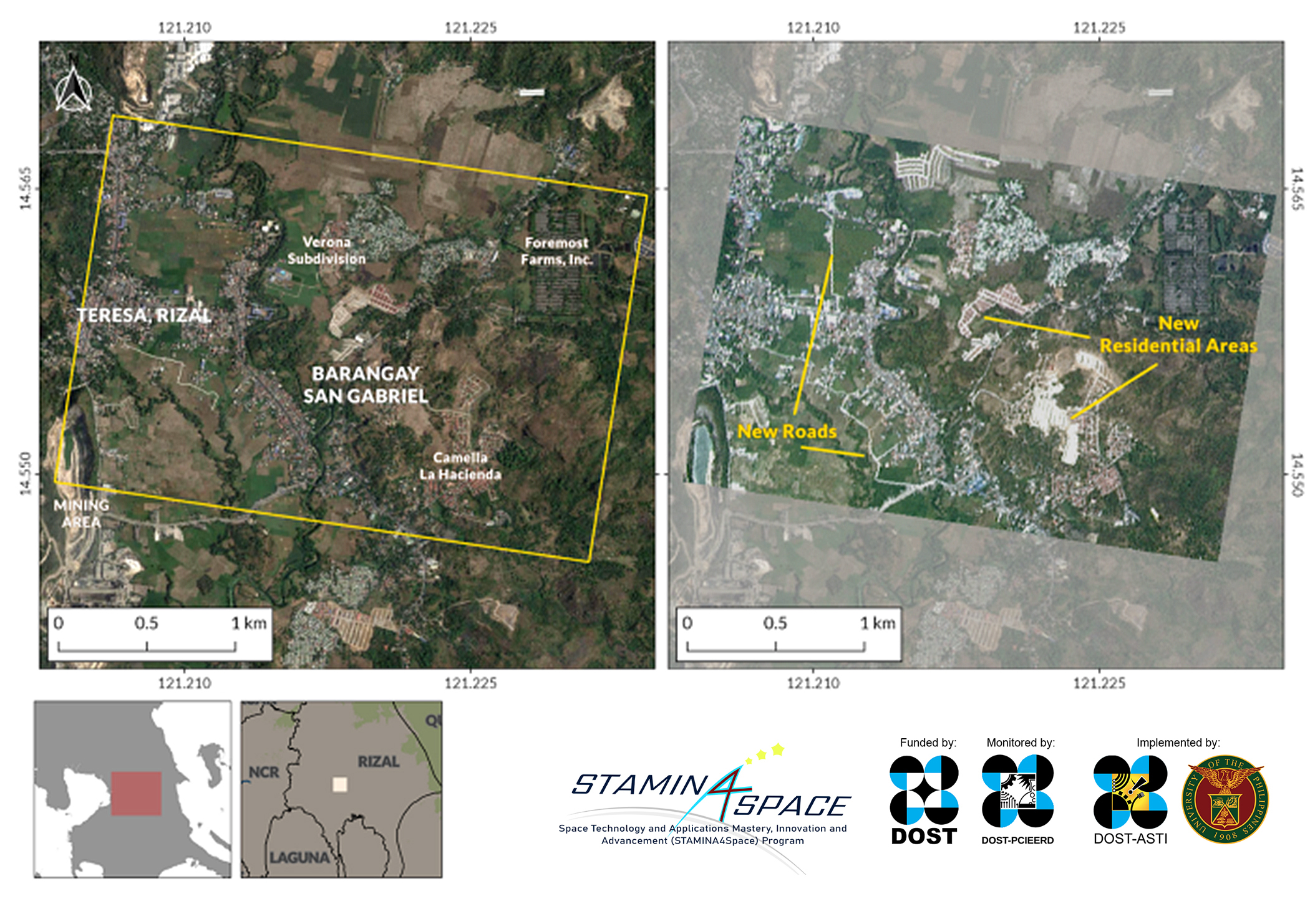
A growing urban sprawl. Captured on March 21, 2019 at around 1:05PM PHT, this Diwata-2 image (right) shows covering parts of the Teresa and Morong municipalities in Rizal. New residential areas and road networks are visible from the Diwata image if compared to the Google Earth image (left) that was taken three years ago.
Residential areas

Land use change. Apparent expansion of road networks as well as new infrastructures as shown in this image captured on March 24, 2016 by Google Earth (left) and in March 21, 2019 by Diwata-2 (right).
Cities in Rizal like Antipolo are becoming increasingly viable residential alternatives due to their proximity to Metro Manila. With economic activities concentrated in the metro, the influx of people consequently increases the need to build settlements. Housing developments have spilled over nearby provinces such as Laguna, Bulacan, as well as Rizal, as seen in the juxtaposed Google Earth and Diwata-2 images. Within that short period of time, small but permanent changes were observed. This implies land conversion or the transformation of land for other purposes. One of the most drastic changes is the loss of agricultural land in the Cavite area due to increasing population.¹ This may also explain the spike in residential areas in the municipality of Teresa in Rizal shown in the Diwata images.

More new developments. New residential areas and mining activities in Teresa and Antipolo in captured by Google Earth in 2016 (left) and in 2019 by Diwata-2 (right). In the image above, we can approximate that there is a 2.7% change as 17.6 ha of vegetative areas were converted into new residential areas.
Mining and quarrying
Rizal’s promising economic potential for mining and quarrying can be attributed to its ideal geological setting, which blesses it high mineral endowment of both metallic and non-metallic mineral deposits.² In fact, Rizal was a pioneer site for mechanized non metallic quarrying in the country, with the first modern mechanized limestone quarry and cement factory built in Binangonan in 1914.³ Diwata-2 was able to image the expansion of the area used for mining between 2016 and 2019.
Satellite images as complementary guides for regulation
As with any significant amount of land use change, regulation can be key to preventing adverse environmental impacts such as soil erosion, flooding, and sedimentation caused by unregulated mining and quarrying. With Diwata-2’s revisit capability, specific areas like these can be monitored regularly.
Images such as these capture the effect of an ongoing process and may depict a picture of an uncertain future where vegetation and other natural resources are lost to permanent land use changes. Left unchecked, uncontrolled expansion coupled with population growth may lead to issues in the allocation of food, water, and basic resources. The capability of Diwata-2, as well as future Philippine earth observation satellites, to capture these type of images is invaluable for future resource management in the country.
References:
¹ Malaque III, I. R., & Yokohari, M. (2007). Urbanization process and the changing agricultural landscape pattern in the urban fringe of Metro Manila, Philippines. Environment and Urbanization, 19(1), 191–206.
² ³ Retrieved from https://www.portal.mediaaccess.com.ph/hard_hat-2013_1st_issue.html
Learn more about Diwata-2 or browse, download, or request for Diwata-2 images.