
Diwata-2 maintained a watchful eye on Typhoon Tisoy (Kammuri) as it devastated the country earlier this week. The satellite captured images of the typhoon on December 2, 2019 from 12:58 to 1:00 p.m. when it was roughly 200 km away from Gubat, Sorsogon.
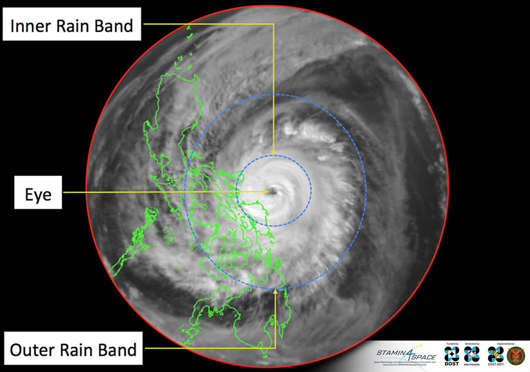
Figure 1. The Anatomy of Typhoon Tisoy. The Wide Field Camera (WFC) image of Typhoon Tisoy before it makes its landfall on Sorsogon. The image was acquired on December 2, 2019 from 12:58:46 to 13:00:52 PHT.
Strong winds and significant amount of rainfall are expected inside the inner band of the typhoon. The inner rain band has a radius of ~134 km from the eye of the typhoon. This distance reaches the northern and eastern Samar, Catanduanes Islands and some areas in Quezon, hence having the storm signals 2 and 3 raised on these areas. The outer rain band of Tisoy has a diameter of ~1050 km. This makes the impact of Tisoy observable even in the Western Visayas and Southern Luzon.
By analyzing the image captured by Diwata-2’s Wide Field Camera (WFC) further, researchers from the Space Technology and Applications Mastery, Innovation and Advancement (STAMINA4Space) Program were able to estimate the intensity of the typhoon through the Dvorak Method. Based on the presence of well-defined eye and curved rain band patterns, a Current Intensity (CI) number of 4.5 was estimated, which is equivalent to a maximum sustained winds of 143 kph. This was validated by the Philippine Atmospheric, Geophysical and Astronomical Services and Administration (PAGASA) weather bulletin released at 2:00 p.m. on December 2, where it reported a maximum sustained winds of 150 kph.
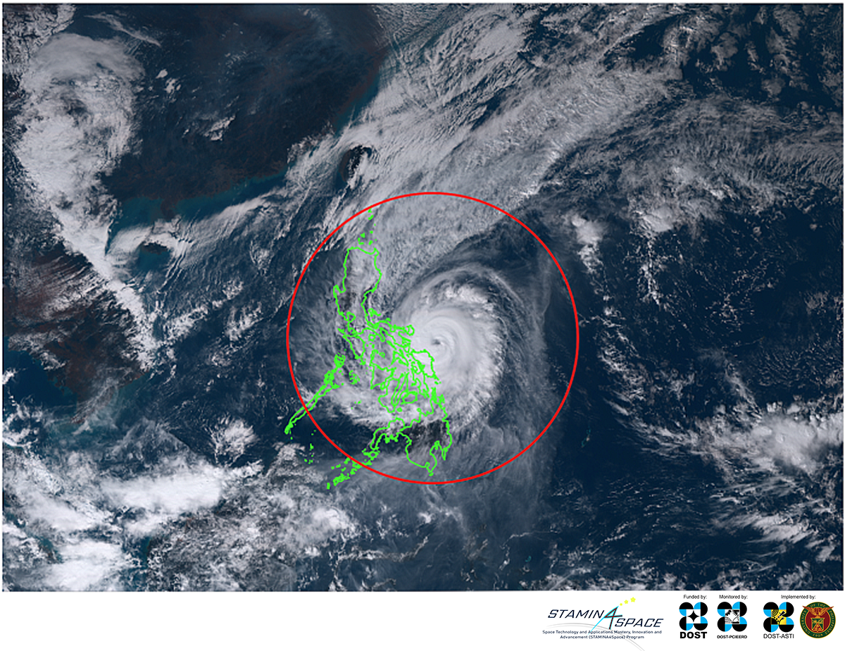
Figure 2. An RGB subset from Himawari-8 acquired on December 2, 2019 at 13:00 PHT. The outline in red circle indicates the extent of area captured using the Wide Field Camera (WFC) of Diwata-2. This image was taken just less than a minute after Diwata-2’s acquisition.
As an Earth-observing microsatellite, Diwata-2 is equipped with cameras such as the WFC which can be used to capture images of cloud patterns and typhoons. Despite being small at 57.3 kg, Diwata-2 was able to capture an image of the typhoon similar to what was observed Japan’s much larger satellite, Himawari-8. Orbiting at a much lower altitude of 600 km from the ground, Diwata-2 captured the full extent of the typhoon due to the wide-angle viewing capability of the WFC. On the other hand, Himawari-8 being situated on a geosynchronous orbit that is 35,800 km from the ground, has a continuous full-disk view of the Earth.
Figure 3. An illustration of Diwata-2, a sun-synchronous orbiting microsatellite with Japan’s geostationary satellite, Himawari-8.
According to the weather bulletin released by the Philippine Atmospheric, Geophysical and Astronomical Services and Administration (PAGASA) at 2:00 p.m. on December 2, Tisoy had maximum sustained winds of 150 kph, validating the estimate of STAMINA4Space.
The latest situational report from National Disaster Risk Reduction and Management Council (NDRRMC) reported 13 dead and 34 injured because of the Typhoon Tisoy. Affected individuals were estimated at 413,833 with 364,003 individuals in evacuation centers.
The final weather bulletin released by PAGASA at 11 a.m. on December 5 shows the eye of the typhoon outside the Philippine Area of Responsibility at 705 km west northwest of Coron, Palawan with winds of 55 kph and gustiness of up to 70 kph.
Read the earlier story here.
References:
Dvorak, V. F. Tropical cyclone intensity analysis using satellite data. NOAA Tech. Rep. 11
PAGASA Severe Weather Bulletin №11. http://pubfiles.pagasa.dost.gov.ph/tamss/weather/bulletin/SWB%2311.pdf
PAGASA Severe Weather Bulletin №26.
http://pubfiles.pagasa.dost.gov.ph/tamss/weather/bulletin/SWB%2326-FINAL.pdf
NDRRMC Situational Report №10 regarding Preparedness Measures and Effects for Typhoon “Tisoy” http://www.ndrrmc.gov.ph/attachments/article/3969/Update_Situational_Report_No_10_re_Response_Actions_and_Effects_Typhoon_TISOY_05_DEC_2019_6AM.pdf
For more Diwata images, visit the Featured Image page.